![]() Anyone who has been in a car crash understands the resulting chaos. Few involved immediately dial 9-1-1 following the rush of adrenaline. Those lost seconds cost lives, according to at least one analysis.
Anyone who has been in a car crash understands the resulting chaos. Few involved immediately dial 9-1-1 following the rush of adrenaline. Those lost seconds cost lives, according to at least one analysis.
More than 140 million Waze App users, meanwhile, constantly pump driving traffic and highway condition information into Waze, alerting peers in nearly real-time. Every day Dallas-Fort Worth Waze users submit more than 10,000 reports of highway incidents and hazards, such as crashes and objects on the road.
Forty-percent of the time, Wazers reports of crashes to the app are almost five minutes faster than traditional 9-1-1 calls, according to an analysis by Waze.
Knowing that, the North Central Texas Communications District (NCT 9-1-1) worked for roughly 18 months to route dispatchers (who work in Public Safety Answer Points, or PSAPs) in the region that same data, giving them nearly equal awareness as drivers on North Texas roads.

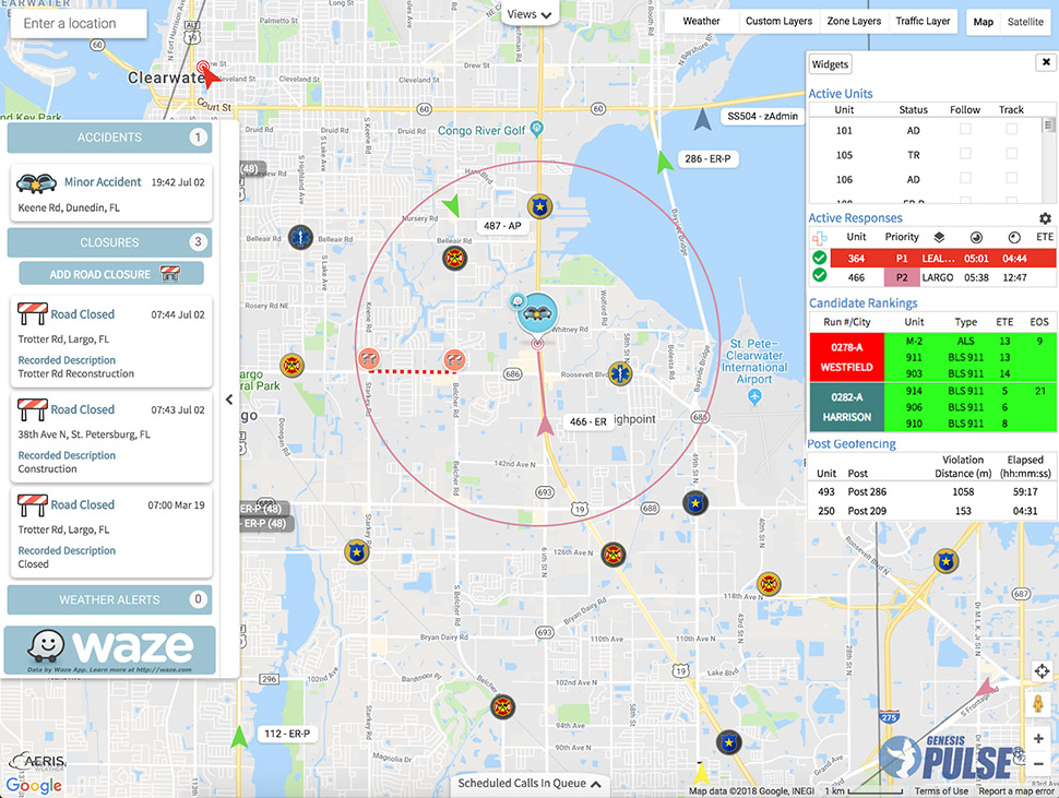
Screenshot courtesy of the Genesis Group
“About 70 percent of our PSAPs are utilizing the (Waze data) service,” writes Rodger Mann, 9-1-1 GIS Manager for the North Central Texas Emergency Communications District, in an email earlier in 2019. “We are confident the others will sign up … as they go through their respective channels for approval.”
NCT 9-1-1 supports more than 40 dispatch centers in nine counties across the region.
How Waze Landed in DFW Emergency Dispatch Centers
Local transportation technology advocate Tom Bamonte—who has been developing relationships with a host of tech, logistics and transportation companies across the world for years—approached Mann with the notion of tapping into the Waze data pool to cut response times. Bamonte is a senior program manager for automated vehicles at the North Central Texas Council of Governments (NCTCOG).
Mann ran the concept past the NCT 9-1-1 Supervisor Committee, which eventually signed off on the project.
In order to coalesce the Waze data into the NCT 9-1-1 framework, Mann and his team connected with East-Texas-based The Genesis Group. That company works with call centers across the U.S. using its web-based Genesis PULSE to integrate Waze data into 9-1-1 dispatch systems.
“First responders that use this (PULSE) software have access to real-time, Wazer-reported crash alerts,” a Waze spokesperson wrote in response to a query from Dallas Innovates. “This can have a major impact on response time. In fact, 40 percent of the time, crashes are reported by Waze users an average of 4.5 minutes before being called into emergency response centers through 9-1-1 or other channels.”
Dispatchers using the PULSE system wed with Waze can see crash reports on their computer screens, allowing them to track the whereabouts of emergency responders. It also helps dispatchers choose the best emergency responder for the call, and allows them to use Waze data to identify the most-direct routes.
“Using Waze’s data, first responders are able to move more safely and quickly through traffic to aid those in need,” according to a statement from Waze to Dallas Innovates.
Integrating Waze data into existing 9-1-1 frameworks was no small feat, according to Mann.
“The biggest challenge was redesigning our Enterprise environment and purchasing a few additional applications, and writing a few custom scripts to aid in filtering and rendering the data,” he writes.
The first NCT 9-1-1 dispatch center went live with Waze data in mid-June 2019, according to Mann.
Global Initiative at a Grassroots Level
Waze is working with more than 1,600 partners around the world in projects similar to the North Central Texas Council of Governments NCTCOG collaboration, according to Waze.
Locally, Fort Worth, Arlington, Plano, Frisco, and other cities have developed such partnerships. Frisco’s use of Waze data in a partnership with its transportation and emergency response departments helped inspire Mann’s efforts. NCTCOG has integrated Waze data into its 511DFW traveler information system.
Through a partnership with NCTCOG on the I-30 corridor between Fort Worth and Dallas, the Texas Department of Transportation is exploring the use of Waze data to improve highway incident response for possible scaling statewide. TxDOT is one of over 25 state departments of transportation that have data sharing partnerships with Waze.
Bamonte credits Mann and his teamwhich also operate as part of the North Central Texas Council of Governments (NCTCOG) for connecting North Texas dispatchers with Waze’s data trove.
“While (my office) may have introduced NCT 9-1-1 to the idea of using Waze incident data to improve roadway emergency response, all of the heavy lifting was done by NCT 9-1-1,” Bamonte writes to Dallas Innovates. “This is a very inspiring story of public sector innovation by NCT 9-1-1 and the network of PSAPs it serves.”


![Dr. Justin Lonon, vice chancellor of Dallas College, addresses the crowd at the recent Goldman Sachs 10,000 Small Businesses Dallas Graduation. [Photo: 10KSB]](https://s24806.pcdn.co/wp-content/uploads/2021/06/GoldmanSachs-10KSB-4992-970-970x464.jpg)


