It’s been 60 years since President Dwight Eisenhower launched an interstate highway system that connected cities while bisecting neighborhoods across the country. These highways have encircled downtowns across America for decades, providing a means of escape or entry for cars and trucks, often at the cost of disconnecting adjacent neighborhoods.
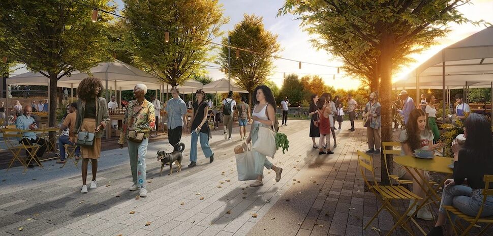
In North Texas, urban planners, transportation experts, activists, and interested citizens have banded together to assemble a plan designed to embrace an approach that is sensitive to both transportation needs and livability of the neighborhoods surrounding Downtown Dallas. In the process, they might have created the secret sauce to reconnect Downtown USA.
This is the story of how the plan, called CityMAP, came to be.
AGING HIGHWAYS AS OPPORTUNITIES
Most solutions present themselves first as problems.
In this case, the highways that surround Downtown Dallas are in need of significant improvement to smooth traffic flows as Dallas-Fort Worth has grown. Rather than simply rebuilding Interstates 30 and 45, U.S. Highway 75 and Interstate 35E, highway officials took a different tack.
Texas Transportation Commissioner Victor Vandergriff called for the creation of an objective team of professionals to bring people together for a more-inclusive conversation.
In response, the Texas Department of Transportation, with the assistance of Dallas-based architecture, civil engineering, and construction management firm HNTB, met with hundreds of people of diverse backgrounds who have an active interest in the neighborhood and its thoroughfares. Members of the public — from elected officials to people who live and work near that area of Dallas — were asked open-ended questions about their ideas and priorities in the process.
CITYMAP HARNESSES CREATIVITY OF RESIDENTS, LEADERS
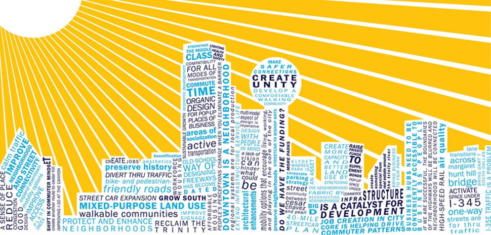
Eighteen months later, the result was the aforementioned City Center Master Assessment Process (CityMAP), TxDOT’s ground-breaking initiative that harnesses the creativity of residents and community leaders and uses their ideas to formulate various scenarios to address traffic problems while reconnecting neighborhoods.
Bringing in neutral planners, landscape architects, engineers, and outreach specialists helped participants free their thinking, said James Frye, lead consultant for HNTB. Frye and deputy project manager Brandi Crawford — both licensed landscape architects through the American Society of Landscape Architects —shepherded the project through its completion.
“There was a sense of neutrality in the consulting team,” Frye said. “When we met with people, it was very conversational. We said, literally, ‘Tell us your thoughts regarding the Dallas downtown freeway network.’ ”
“There was a sense of neutrality in the consulting team.”
James Frye
The feedback was sometimes surprising.
“For example, some people asked, ‘How do we fix schools, or how do we bring the middle class back downtown?” Frye said.
Some participants in CityMAP reasoned that if development and planning were done right, it could foster additional development that would substantially increase land values, boosting property tax funds for school districts.
Many recurring thoughts or themes found their ways into CityMAP as scenarios, which planners assembled, right down to the city-block level.
The geographic area discussed by participants encompassed 30 miles of freeway and land near highways. Hundreds of conversations, ideas, and interactions later, planners assembled eight geographically-specific scenarios that addressed recurring points of public interest.
BEGINNING WITH A BLANK SLATE
One scenario in the study outlined the impacts of removing I-345: The scenario would open space for retail, residential, and/or commercial developments, and would allow for some small parks. CityMAP estimated that within a 25-year period, the removal of the highway could foster up to $500 million in development, boosting neighborhood property values by about $2.5 million, adding 39,000 jobs, and increasing property tax revenue by $80 million.
Estimates of development and tax revenue also were developed for related scenarios that would modify the existing I-345 or move the highway below ground.
Another scenario focused on Dallas’ southern gateway: a two-mile stretch of land along Interstate I-35E, including the Dallas Zoo. The concept for that stretch of highway would include sunken lanes, similar to Dallas’ North Central Expressway, and a deck park, similar to Dallas’ Klyde Warren Park. Planners projected those and other improvements would bring about $167 million in new land value and nearly 1,000 new jobs. The estimated cost for that scenario: $662 million.
OFF THE PAPER, ON THE RADAR
The potential of Dallas’ CityMAP plan has gained the attention of Dallas’ real estate developer/investment community, and the city of Dallas.
Dallas Assistant City Manager Majed Al-Ghafry said the objective, open-ended nature of CityMAP makes it valuable.
“It’s a fresh look at what we, the community, desire, without biased opinions or fiscal constraint.”
Majed Al-Ghafry
“It’s a fresh look at what we, the community, desire, without biased opinions or fiscal constraint,” Al-Ghafry wrote, in an email on the topic.
The Real Estate Council (TREC) member and INVESCO senior director Sam Gillespie said CityMAP’s blend of specifics — right down to dollar estimates — and conceptual planning make it too valuable not to use.
“You don’t want this incredible document to sit on the shelf,” said Gillespie, chairman for the CityMAP sub-committee within TREC’s Mobility Working Group.
Gillespie said CityMAP’s emphasis on reconnecting neighborhoods while improving traffic flow were key elements in drawing support from the group.
“Mobility is a core, core issue for The Real Estate Council,” said Gillespie, a member of TREC’s Mobility Task Force. “The economic health and vitality are dependent upon a strong central city, which is dependent on the strong transportation network.”
Gillespie said the task force’s 25-member committee is especially interested the I-30/I-345 corridor, and will likely create a series of recommendations for that area, and present them in October.
“TREC is going to get behind this,” Gillespie said. “We’ve got 2,000 members, and we’re going to raise awareness among the membership,” adding that TREC successfully championed the underground version of Dallas’ second downtown light rail line.
“The economic health and vitality are dependent upon a strong central city, which is dependent on the strong transportation network.”
Sam Gillespie
Gillespie said if anyone needs an example of the transformative power of reconnecting neighborhoods via foot and bicycle traffic, they need look no further than the Klyde Warren deck park.
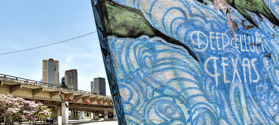
“I haven’t done the math, but what’s been the investment in that area?” he asked, alluding to the booming construction projects surrounding the 5-acre park that arches over the Woodall Rodgers Freeway, and connects Downtown Dallas to Uptown Dallas. That includes the $200 million Museum Tower project, the Hunt Oil Company headquarters, and others. “Billions. We can do the same thing connecting I-30 and I-345, connecting South Dallas to Deep Ellum. Connecting downtown to Fair Park … a deck park could be part of it.”
DIFFERENT THINKING, DIFFERENT SOLUTIONS
Frye compares the CityMAP process to building a custom home, rather than a mass-produced home.
“You wouldn’t design a house without talking to the customers,” he said. “We’re not building a spec home. We’re trying to design something that meets the needs of a city long-term. That also impacts the region and regional development patterns.”
Frye added: “I think what worked very, very well was, before putting pen to paper, was talking to people and really understanding. It saves time and money. You’re not designing based on one need.”
Public policy and planning experts say the CityMAP process is a step above a more traditional corridor feasibility study (which is a combination of preliminary conceptual engineering, environmental impact assessments, public outreach, and agency coordination), because CityMAP literally covers more ground, and identifies positives and negatives of scenarios earlier in the planning process.
“I think what worked very, very well was, before putting pen to paper, was talking to people and really understanding.”
James Frye
In addition to collecting input from individuals, HNTB and consultant team member Kimley-Horn and Associates Inc. used advanced tech to get a more complete picture of where traffic goes when it converges in Downtown Dallas.
Consultants did so by installing 34 Bluetooth signal-capturing devices along highways leading into and out of the downtown area; those devices captured Bluetooth signals emitted from vehicles, and from drivers’ smart phones. That data — which didn’t include confidential cell phone information — was then analyzed to allow researchers to count the number of drivers commuting and staying in the city, and the number of vehicles that kept moving on.
Cameras were also deployed to allow analysts to determine how many of the vehicles were cars and light trucks, and heavy trucks. The analysis of Bluetooth data adds complementary information for CityMAP scenarios.
The CityMAP process would work in other communities as well, planners say.
“It’s absolutely scalable,” said Frye. “Every city has its own personality. Neighborhoods are different. The demographics and the politics are different.”
Victor Vandergriff, who inspired the inaugural CityMAP study, said the final, 426-page document helped the concepts discussed during listening sessions take form.
“CityMAP illustrates what TxDOT and other DOTs can do when they sit down together with local stakeholders and discuss the art of the possible,” he said. “This effort, in going beyond TxDOT’s typical project planning outreach, shows how dreams and visions can be developed long before any formal corridor studies even begin.”
“CityMAP illustrates what TxDOT and other DOTs can do when they sit down together with local stakeholders and discuss the art of the possible.”
Victor Vandergriff
Frye said the CityMAP planning process has been presented at 17 events across Texas, including at the November gathering of the Texas Chapter of the American Planning Association conference in San Antonio. CityMAP also has received the 2016 Texas American Council of Engineering Companies Silver Award.
Dallas’ full CityMAP report stops short of recommending any specific courses of action, however.
“That decision rests with the taxpayer and community leadership,” says the executive summary of the CityMAP project.
Will other cities follow Dallas’ path?
“I think lots of people are waiting to see what happens,” Frye said.
“Where we go from here is going to be very important. The beauty of this so far, has been the collaboration, the sharing of ideas, the working together, the spirit of camaraderie that was built,” he said. “We presented the ideas and now the hard part is that they just need to move forward. Now, the city of Dallas and other partner agencies have to inform the state as to what Dallas’ priorities are. That prioritization will need to be established and agreed upon and formalized by all parties.”
Aside from Raleigh, N.C.-based transportation and infrastructure consulting firm Kimley-Horn and Associates Inc., subcontractors working on CityMAP included Dallas-based Gateway Planning Group Inc. (for urban design/economic development); Dallas-based Catalyst Commercial Inc. (for economics); Dallas-based EJES Inc. (engineering/cost estimation); and Fort Worth-based OCG PR (for public engagement).
This article previously appeared in the Dallas-Fort Worth Real Estate Review.
READ NEXT
CityMAP Plots Transformational Path for Downtown Highways
Dallas Innovates, every day
R E A D N E X T
-
The hybrid event in August will take place in person at SMU and virtually. The seventh annual Dallas Startup Week powered by Capital One is Dallas-Fort Worth's largest event focused on driving entrepreneurial success, economic impact, and innovation in the region.
-

You'll find deadlines coming up for a new accelerator program; and many more opportunities.
-

Five local winners received up to $200,000 in funding to activate their solutions throughout North Texas.
-

In this weekly roundup of executive moves in North Texas, you'll also find news from Operation Kindness, Cooksey Communications, Munck Wilson Mandala, and StoneEagle F&I.